Saturday, February 27, 2010
Geography Homework - Earthquake in Egypt
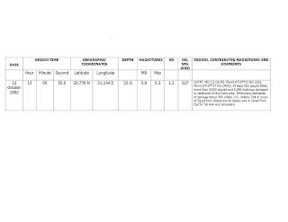
On October 12 1992, at 3.10 pm, a strong earthquake hit near Cairo. Significant sand-boil activities and liquefaction at several locations happened on both sides of the Nile River near the earthquake epicentre, thus causing the crustal plates to move more than it’s usual. It registered 5.9 on the Richter scale.(summary in the table below)
The extent of the damages included 205 buildings being toppled and 3759 severely damaged buildings. Approximately 370 lives were lost and thousands injured. The quake could be felt as far away as Jerusalem, 250 miles northeast of Cairo.
In response to the earthquake, the government established the National Earthquake Network. The network comprises of 60 monitoring stations nationwide and is responsible for identifying areas with considerable quake activity and compiling a map of Egyptian quake zones.
The major reason for the extent of the damage is due to the bad condition of the buildings in Cairo. In the wake of the quake, it was "discovered" that 10,722 floors in Cairo were built without license in addition to 170 buildings which violated building codes. The Ministry of Housing concluded at the time that all in all, 96 per cent of the buildings in Cairo and 85 per cent of the buildings in Giza violated the building codes one way or another. In my opinion, 1 way of minimizing the damage from such events is by having a sound infrastructure. And to achieve this, the government needs to set up proper bodies to help to ensure that the buildings are built to withstand earthquakes and meets international standards.

Subscribe to:
Comments (Atom)
